| Friends of Alewife Reservation (FAR)
|
|
|
|
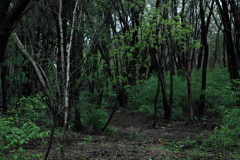
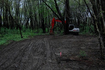
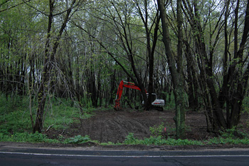
Uplands testing on Acorn Park Drive Crossing 100 Year Flood plain demarcation without permit. Necessary clear cutting? Photos by Don Bockler. Letter from O'Neill attorney.
Photos that I took on May 16, 2006 of the newly cleared area in the Alewife Reservation uplands area. I took the photos mid-afternoon betweeen bouts of rain, so the trees were rather dark. The lawyer for O'Neill arrived to take his own photos as I started to shoot mine from the road along Acorn Park Drive.
Letter to Belmont Conservation Commission, on activity in buffer zone,
Link to letter as PDF file (with original formatting, including letterhead and Community Development date-of-receipt stamp) Nutter Miriam Weil, Chairman My client, O'Neill Properties Group, LLP, and I have been forwarded a copy of your May 15, 2006 e-mail to David Albrecht of Rizzo Associates ( Rizzo ) wherein you asked "Are you doing anything in the buffer zone on the O'Neill property? If so, you need to come to the con com. My client has requested that I write to you to explain what has been done on the property, why it was done and the basis upon which we concluded that they did not need conservation commission approval before proceeding. As you may know, one issue that has been raised thus far in the hearing process is the ability of the soil on the property to infiltrate water as modeled in Rizzo's drainage calculations. This issue has been raised by the Zoning Board of Appeals' (ZBA) peer review consultant Fay Spofford & Thorndike, LLC (FST), as well as citizens groups opposing my client's project. To perform the drainage calculations initially Rizzo used soil classifications for the property shown on Soil Conservation Service maps. While using such data is accepted standard engineering practice, particularly in a process governed by M.G.L. c.40B, the most accurate method to determine the seasonal high groundwater elevation and infiltration rate is through digging test pits and performing percolation tests. Such tests were requested by FST in their April 27, 2006 letter to the ZBA. Accordingly, my client authorized such test pits to be dug and percolation tests performed to provide Rizzo the detailed information requested to support Rizzo's drainage Nutter McClennen & Fish LLP Attorneys at Law Miriam Weil, Chairman calculations and design. Test pits and percolation tests were to be performed in the areas designated for construction of stormwater management structures. As such, on Thursday and Friday, May 11th and 12th, a backhoe, directed by Rizzo performed such tests. From looking at the project plans on file with the ZBA you will no doubt notice that some of the activity is within the 100' buffer to bordering vegetated wetlands (BVW) and possibly within the 200 foot riverfront buffer zone. However, as explained below, state wetland regulations allow such activity without approval of the Conservation Commission. Admittedly, most activities within buffer zones are subject to Conservation Commission pre-approval, but the state wetland regulations provide exemptions for certain activities that have been determined to be minor and temporary in nature. With respect to the buffer to BVW, 310 CMR 10.02(2)(b)(1) provides in pertinent part "Minor activities within the buffer zone and outside any areas specified in 310 CMR 10.02(b)(1) a through g are not subject to regulation under M.G.L. c. 131, §40." Thereafter, subsection "g" provides an exemption for "Activities that are temporary in nature have negligible impacts, and are necessary for planning and design purposes (e.g. installation of monitoring wells, exploratory borings, sediment sampling and surveying)." To the extent some of the tests were within the 200 foot river front zone, 310 CMR 10.58(6)(b) incorporates the "minor activities" exempted pursuant to 310 CMR 10.02(2)(b)l and likewise exempts such activities from jurisdiction. All work performed on the property to date qualifies for the above cited exemption. Thank you for your attention to this matter. Please call if you have any questions or comments.
Very truly yours, |