| Friends of Alewife Reservation (FAR)
|
|
|
|
|
Bulfinch Consultants Respond to Conservation Commission and other Organizational and Individual Comment Letters and Reports For more comments about the environment and how to improve it, please send to FAR. Also respond on the forum page. See also: Microsoft Word version of the text below, for easy printing. |
This scanned map accompanied the text below:
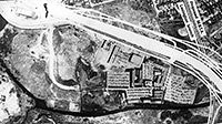
large (original) version of map
|
Response to Comments and Questions The following is prepared in response to the Conservation Commission’s August 26, 2004 summary of Comments and Questions. The responses are provided in the same order in which the comments and questions were submitted.August 9, 2004
Question 1: How can this project be permitted in phases without allowing segmentation? Can the Commission permit the master plan instead of the individual phases?
The overall project to redevelop Cambridge Discovery Park will involve master planning for the demolition and replacement of all the existing buildings and the expansion of gross floor area up to approximately 826,000 square feet and is anticipated to occur over a period of several years. In the case of Cambridge Discovery Park, in addition to the Conservation Commission’s jurisdiction over the entire site, the Secretary of the Executive Office of Environmental Affairs has required a review of the full redevelopment project under the Massachusetts Environmental Policy Act, and the Cambridge Planning Board will implement the requirements of Special District 4, established for this redevelopment. The rezoning established specific milestones for the restoration of portions of Cambridge Discovery Park to natural conditions as the total gross floor area is increased.
During the first stage, the zoning requires Bulfinch to terminate all use of the MDC lot for parking and develop plans for the eventual restoration of the MDC lot and the Little River Area to meadow conditions. In exchange, the Special District 4 zoning will allow Bulfinch to increase the net gross floor area and to construct structured parking. Under the zoning, the actual restoration activities do not need to occur until the total gross floor area is increased to 666,000 square feet. In fact, Bulfinch plans to remove the pavement from the MDC lot as part of the first building project and to restore the MDC Lot and the footprint of Building 20A to natural conditions now. As implementation of the master plan proceeds, Bulfinch will be required to demolish the remaining buildings in the Little River Area, and restore that area to natural conditions.
Therefore, the master planning commitments with respect to open space are pre-established by zoning (i.e. they are not subject to change or variation based on a developer’s interests), and compliance will be reviewed by the state and dictated by the City. The Conservation Commission’s request regarding segmentation relates not only to the open space commitments but also to a net compliance with the performance standards of the MA Wetlands Protection Act, specifically as the project may affect Bordering Land Subject to Flooding (BLSF). No direct impacts are proposed to any other wetland resource areas, with the possible exception of improvements to Bordering Vegetated Wetland (see later questions). There will be activities in the Buffer Zone and in BLSF. As the Commission is aware, all project activities will occur in BLSF and will require full compliance with the performance standards.
The issue of segmentation arises when there is a potential that by only presenting a small portion or segment of a larger project, the project will avoid the need to comply with certain regulatory requirements or performance standards. Because every future building also will require an Order of Conditions for work in BLSF, those segmentation concerns do not apply to this project. At present, Bulfinch is unable to submit a Notice of Intent for the full re-development because engineering design cannot be prepared without knowing building footprint locations, elevations, and stormwater treatment details. Details of future buildings will depend, in part, on the needs of future tenants. As the Commission is aware, the directions for submittal of a Notice of Intent require detailed engineering plans and drainage calculations.
However, Bulfinch is required by zoning and by the Wetlands Protection Act to ensure compliance with the performance standards for Bordering Land Subject to Flooding by removal of buildings and by working with the Commission and the Planning Board regarding low impact development commitments and achieving compensatory flood storage for the development. Additionally, the Conservation Commission will be reviewing individual Notices of Intent for each future building or phase of the redevelopment. Specific Orders can be written into the Building 100 Project Order of Conditions specifying the amount of excess flood storage capacity that is to be banked for future phases of the project.
Based on discussions with the Commission on August 9, the Commission has previously issued Orders of Conditions allowing the a carry-over of a resource area performance standard, in this case, the “banking” of Bordering Land Subject to Flooding from phase to phase. The details of the “banking” can be set forth as a Condition of each Order of Conditions issued for the project.
Question 2: More information is requested on the existing and proposed plantings. What is the net removal and replacement of trees? Can the Applicant provide a table?
See Table below for Phase One only. Detailed information for future phases is not available because proposed site details are not known at this time.
Approximate Tree Removal and Proposed Plant Material Quantities
Question 3: The Commission would like the Applicant to provide an invasive species management plan.
The most visible invasive species on the property are Phragmites australis, Common Reed, and Lythrum salicaria, Purple Loosestrife. In addition, smaller amounts of honeysuckle species, (Lonicera sp.), Reed Canary Grass, (Phalaris arundinacea), Common or European Buckthorn, (Rhamnus cathartica), Japanese Knotweed (Polygunum cuspidatum), and other species typical of disturbed conditions exist on the property although they have not yet reached the state of incursion that the Common Reed and the Purple Loosestrife have achieved.
As the Commission is aware, treatment of invasive species is very dependent on growth form, and species location in relation to water, non-invasive trees, and other factors. The use of herbicides is often one of the few treatment methods for such species as Phragmites and Japanese Knotweed, whereas limited amounts of Buckthorn and Honeysuckle can be pulled with a weed wrench.
Invasive species maintenance is not a short term project. Monitoring and repeat management techniques are critical. In addition, in some circumstances, aggressive invasive species management on one property without maintaining other adjacent properties is futile.
As part of the EIR preparation process, Bulfinch will explore invasive species management alternatives and develop an invasive species management program. Most, if not all, of the elements of such a program likely will require Conservation Commission approval, and Bulfinch will submit a Notice of Intent and supporting documentation to the Commission seeking approval of the program.
Question 4: What will be the total reduction in impervious surface?
As stated in our Drainage Report for the project dated July 30, 2004, the total reduction in impervious area at Cambridge Discovery Park for the Building 100 Project is estimated to be 1.24 acres. In addition, more than 3 acres of impervious pavement area will be removed from the MDC Lot.
The Drainage Report did not calculate the impervious for intermediate phases of the development nor for the Master Plan. However, impervious calculations will be submitted before the next Hearing, per the Conservation Commission’s request. The total reduction (from existing conditions) in impervious area at Cambridge Discovery Park for the Master Plan is estimated to be 3.1 acres (plus 3+ acres on the MDC Lot).
Question 5: Has a study of the bordering vegetated wetland been completed; including but not limited to the evaluation of the plant species and ecological health?
A formal study of the ecological health of the Bordering Vegetated Wetland has not been conducted, however, an informal evaluation of species and successional condition has been made. See also answer to question 3 above. The site is in a transitional condition where early successional vegetation, such as the cottonwoods discussed in the Notice of Intent and patches of Staghorn Sumac (Rhus typhina), are at their peak maturity. The site was almost completely altered in the early to mid 20th century for industrial and commercial land uses. Since the 1940s and ‘50s, the construction of Route 2, and later of Acorn Park Drive, the diversion of the Little River, and the construction of the Acorn Park campus, left the site almost completely devoid of trees or vegetation. See Figure 1. The meadows that were dominant on the site approximately 25 years ago have reverted to wooded conditions, such as the silver maple forest on the Belmont Uplands and the fields facing the Little River south of Acorn Park roadway.
From an ecological health point of view, the Bordering Vegetated Wetlands (BVW) are able to function successfully to meet the performance standards established in the Wetlands Protection Act regulations. For example, there is an unrestricted exchange of surface water and ground water, the BVW provides wildlife habitat for a wide range of species. There is a diversity of wooded swamp and wet meadow, and the floodplain assists in the moderation of temperatures that contribute to fish habitat. The impact of human alteration to the BVW, however, has been and continues to be extensive. Water quality is compromised by combined sewer overflow and excessive sedimentation from urban runoff, invasive species reduce what could be a significantly diverse ecological community, past fill has altered the natural characteristics of the soils, and fisheries habitat has been seriously altered by poor water quality and introduction of invasive fish species, such as carp.
From a positive point of view, as has been noted in the Friends of Alewife Alewife Ecology Guide and Biodiversity of the Alewife Reservation Area: Species, Habitat, and Ecosystems, as well as comments submitted in response to the Expanded ENF and the Notice of Intent, many wildlife species noted in 19th century writings are returning to the reservation. The improvements to stormwater quality, increase in open space, and maintenance of open lands to encourage successional diversity will aid in the ecological restoration of the reservation.
Question 6: How can the bordering vegetated wetland be enhanced and improved?
Many of the Bordering Vegetated Wetlands have been significantly altered by fill, grading, and negligence. Enhancement can be conducted through coordination with DCR and through invasives species management. The initial Building 100 Project will begin the process of treating and directing to the wetlands area stormwater flows from on- and off-site which currently sheet flow without treatment, discharge to the Cambridge sewer system, or discharge directly to the Little River. Directing these flows through the wetlands should help manage invasive species and provide increased open water habitat. See also answers to earlier questions for more description.
Question 7: What is the status of the re-vegetation plan for the “MDC parking lot”?
Carol Johnson Associates, Inc. has designed an initial revegetation plan for the MDC Lot. As required by the Special District 4 zoning, this plan was submitted to the Cambridge Planning Board as part of the Cambridge Discovery Park special permit application (Appendix V). BSC Group is preparing a Notice of Intent for this restoration plan, which will be submitted to the Conservation Commission in the near future.
August 20, 2004
Question 9: Given that there are varying estimates as to the accurate flood elevation on the site, and that the current FEMA estimate is being revised, and that the new FEMA number will not be available for some time, what impact does this uncertainty have on the Applicant’s plans to move forward with development?
None. Building 100 and the initial parking garage have been designed based on a 100-year flood elevation of 10.8 feet NGVD, a conservative estimate provided by ENSR International (FEMA’s consultant) of the maximum elevation to which that level might be increased. Please be informed that this elevation is a preliminary elevation based on ENSR’s ongoing flood study and is based on the Cornell methodology (i.e. assumes higher rainfall amounts). Please note that this elevation is preliminary and is subject to downward revision and should not be considered final by FEMA.
Master Plan design studies also have been based on this elevation. If, as expected, the ultimately-adopted new FEMA elevation is less than 10.8 feet then future buildings can have their first floor levels set slightly lower and less compensatory flood storage will be required (because the planned flood storage between the actual, final elevation and 10.8 feet will not be needed).
Question 10: Will higher FEMA elevations change any design plans on the site?
No, the Building 100 Project and the Master Plan have been designed based on a projected maximum 100-year flood elevation of 10.8 feet NGVD (see response to Comment 10 above). As ENSR’s modeling already indicates that this estimate is conservative, i.e., higher than ENSR expects to recommend to FEMA, we do not anticipate needing to design for an even higher elevation.
Question 11: For the purposes of clarity, please describe the relationship of the work on the MDC parking lot to a.) the CDP project as a whole, and b.) Phase 1 of the CDP project.
The Special District 4 zoning requires that, as part of the initial expansion of Cambridge Discovery Park, Bulfinch must prepare and submit to the Planning Board a plan to restore the MDC Lot to natural conditions, and seek the Conservation Commission’s approval of the plan. This plan is included in Bulfinch’s special permit application, and a Notice of Intent for the work will be submitted to the Commission in the near future. Although the zoning does not require that the actual restoration occur until the project’s gross floor area exceeds 666,000 square feet, Bulfinch proposes to undertake the restoration in connection with the initial Building 100 Project.
Question 12: The retention ponds on the western edge of the site have been presented to the Commission as optional components of the design plan. What criteria does the Applicant feel the Conservation Commission should use to determine the value of including those ponds in the design?
The amount of treatment is hard to assess because the pond is not sized to provide full treatment for the upstream watershed so treatment falls somewhere between no treatment and full treatment. While hard to measure precisely, some benefits of the pond are:
· Provides some recharge · Provides some flood storage · Provides additional TSS and pollutant removal, such as bacteria. · Provides a physical means for hydraulically pulsing the adjacent wetlands
The greatest benefit that the pond is likely to provide is during frequent rainfall events of short duration (i.e. quick passing rain that provides just enough runoff to clean the streets). The catch basins and Vortechnics unit will provide most of the treatment and the ponds will provide additional pollutant attenuation for what may bypass those BMP’s.
The projects stormwater management systems have been designed to achieve greater than 80% TSS removal without relying on the ponds. Rather, the pond will provide some very useful benefits to the area’s ecology beyond the requirements of the Wetlands Protection Act.
Question 13: Under current plans, what is the fate of the Cottonwood trees on the west of the current parking lots?
The locations of the cottonwood trees have been shown on the site plans. The tree closest to Acorn Park roadway will be removed as a result of the proposed access road around Building 100. The tree in the vicinity of the proposed detention pond can only be preserved if the pond is eliminated.
Question 14: At the last hearing, the Applicant discussed with the Commission a proposed condition that would require the Applicant to study revitalizing the wetland areas west of the current parking lots. Please describe how that condition would function, and what would constitute fulfillment of that condition. A condition allowing an increased volume of stormwater to enter the central wetland (via the proposed stormwater ponds) would potentially reduce the stagnant conditions of the wetland. Phragmites are known to thrive in disturbed or polluted soils (low aeration) and in areas with increased sedimentation.[3] Our goal is to introduce a new source of water that would potentially slow or reverse the growth pattern of the Phragmites within the eastern portion of the wetland area (i.e. the area adjacent to the outlet of the detention pond).
Any effort at controlling the Phragmites in this manner would be experimental at this point, but would contribute to the growing evaluation of Phragmites control methods. The results of the effort would identify the rate of discharge into the swamp and then monitor over a period of 3 to 5 years whether there is a change in the growth patterns. Plots would be set up and monitored once a year. Photo plots would visually document changes or lack thereof, and measurements would be taken to document the area of open water, evidence of broken or dead stems, depth of water, and depth and type of substratum. Before initiation of increased flows into the wetland, the base line condition would be documented.
Other ways of controlling Phragmites include raising water levels or increasing flood duration for up to 4 months per year, which may not be an option on this site due to changes to other aspects of the Bordering Vegetated Wetland.
Question 15: Under the current plan, when would the south side of Acorn Park Drive be clear of all buildings and other impervious surfaces?
The Special District 4 zoning requires that five buildings in that area must be demolished as part of expanding the total gross floor area beyond 666,000 square feet, with Building 20A to be demolished in connection with the final phase of expansion. In fact, Building 20A will be demolished (and its footprint restored to Green Area Open Space) as part of the Building 100 Project. The timing of the removal of the other buildings and impervious surfaces will depend on market conditions, i.e., how long it takes to develop the full Master Plan.
Question 16: A question about the phrasing of Storm Water Pollution Prevention Plan (SWPPP): The plan, as included in the Drainage Report, uses the words “shall” and “should” (e.g., “Runoff should be diverted from disturbed side slopes in both cut and fill.” P.22). Simply as a matter of English, such a statement does not seem to bind the Applicant to any action. It seems only to recommend that the Applicant do something. How does the Applicant understand the wording of their SWPPP as presented in their Drainage Report? The word "should" will be replaced with the word "shall". In general, the word "should" as used in the SWPPP was used as a means of explaining the preferred way to accomplish something and can easily be changed to “shall”.
Question 17: The Applicant has agreed to detail out their phasing scheme with greater clarity for the upcoming meeting, and we look forward to hearing from them about. (In particular, how they propose to carry flood storage “forward” in their project.)
See also response to Question 1, dated August 9, 2004.
Regarding impervious pavement, the Applicant proposes to compare each phase of the new development with the existing conditions of 2004. For example, the construction of Building 200 should compare its total post-construction impervious area with the currently existing impervious of 2004, rather than with the conditions immediately after construction of the Building 100 Project. To do otherwise would penalize the applicant for maximizing green area open space during intermediate phases, and would encourage the retention of unneeded impervious cover.
Case in point, the construction of Building 200 will require more impervious area when compared to the total impervious pavements at the completion of the Building 100 Project but does not have more impervious pavements when compared to the existing conditions of 2004. (These calculations will be provided to the Commission prior to the next Hearing.) The Alewife area will benefit greatly if the Building 100 Project provides a larger amount of grass than pavement. However, basing impervious calculations for the subsequent Building 200 on then-existing conditions, rather than on a comparison to the current would provide a strong disincentive against maximizing green area during the initial construction.
Regarding flood storage, flood storage calculations performed for a construction phase will be compared to its previous construction phase, including available flood storage structures built under the previous phase as a means of mitigation. Flood storage capacity will never be decreased below current conditions for any incremental elevation. When a particular construction phase results in the creation of additional flood storage capacity at a particular incremental elevation(s), the applicant has requested permission – consistent with past Commission practice – to carry the surplus forward to be used as a credit in the next phase. This means of “carrying forward” guarantees that each subsequent construction phase will not create more flooding than the previous construction phase.
Question 18: The Applicant has also agreed to do a calculation of the situation at total buildout, given the current master plan, and we look forward to seeing that estimate.
See response to Comment 17 above.
Question 19: Proposed work on western portion of site in buffer zone to BVW: The Applicant needs to demonstrate that the proposed activities and structures in the buffer zone to bordering vegetated wetland (e.g. removal of existing vegetation and construction of new road, portions of buildings and related building structures, stormwater basin) would not negatively effect the protected functions of the bordering wetland. Please demonstrate how the proposed alterations in the buffer zone would not negatively affect the following functions of the bordering BVW: hydrology, flood control, storm damage control, pollution control, and aquatic and terrestrial wildlife habitat.
Buffer zone activities along the western portion of the redevelopment include the removal of the helipad, the construction of a proposed stormwater basin, and construction of an access drive and other structures. Without a doubt, the activities within the buffer zone will affect the BVW. Overstory trees will be removed and there will be a slight net increase in impervious surface in this area. Currently, untreated stormwater sheet flows via the buffer zone to the BVW. After construction of the proposed improvements in the buffer zone, this stormwater will be treated in accordance with the DEP Stormwater Policy. Mitigation will include some replacement plantings and the proposed basin may result in an improvement to the current stagnant conditions of the wetland in this area. (See also response to question 14.) In addition, it is the Applicant’s hope that the overall improvements to wetland resource areas on the site will more than compensate for the proposed activities along this portion of the site.
Additional Question and Comments Submitted by the Public
A. Attachment A: Letter dated August 16, 2004 submitted by Stephen H. Kaiser. Responses to SPECIFIC QUESTIONS FOR THE PROPONENT, page 6:
1. Comment noted. No response required. 2. 2a and 2b: Available flood storage calculations have been made for Building 100 and the lowest level of the garage, as shown in the Drainage Report submitted as part of the NOI submission package.
2c: The Applicant disagrees with comment 2c. These buildings are not considered existing flood storage. They can be and have been flood-proofed during significant flooding events and are calculated accordingly.
2d. We appreciate that this commenter (and others) recognize the environmental benefits that will result from the removal of impervious material from the MDC lot. The Applicant would welcome the ability to include the MDC lot as part of their project for flood storage calculations purposes. However, the MDC lot is not owned by the Applicant and cannot be included in the project’s calculations. None of the project’s calculations included the MDC lot. 3. It is anticipated that ENSR will establish the floodway boundaries as part of their FEMA flood study update. 4. BSC’s work (existing condition elevations and contours, proposed grading and flood storage elevations, etc.) has been based on 1929 NGVD, which is the datum used for the current 1982 FEMA flood study, i.e. for the current FEMA map. ENSR is doing their flood modeling based on the newer 1988 NAVD datum. BSC converted ENSR’s estimated flood elevation (Elevation 10.0 1988 NAVD) to the 1929 datum by adding 0.8 feet (the actual conversion is to add 0.82 feet but the flood elevation estimate was rounded to the nearest tenth). This difference in base data explains part of the difference in flood elevation numbers. Also, ENSR is using a more conservative rainfall model (the Cornell model) than has previously been accepted by FEMA for this area. The heavier rainfall levels assumed in ENSR’s model account for much of the remaining difference in flood elevation numbers. The benchmark used for BSC’s work is the Massachusetts Geodetic Survey Benchmark MCR-16, elevation 9.06, 1929 NGVD. BSC will work with the City and Mr. Kaiser to integrate Mr. Kaiser’s data with the project’s. 5. The Applicant has been and will continue to monitor the FEMA flood study update. 6. The Discovery Park wastewater pump station has sufficient capacity to handle sanitary wastewater and infiltration/inflow from its tributary area during a 1-year storm. Therefore, there is no potential for the discharge of wastewater directly from the site to the Alewife Brook during this type of event. However, because the Discovery Park pump station discharges to the City of Cambridge wastewater collection system in an area where there are several downstream combined sewer overflows, the Building 100 Project will include a wastewater holding tank for Building 100. The purpose of this tank will be to detain wastewater at the site during downstream CSO activations. The holding volume will exceed that needed for a 1-year storm event. A similar approach is contemplated for the buildout of the remainder of the development. 7. The flooding that occurs at Cambridge Discovery Park is not a high velocity flood. Water essentially backs up and over the Little River banks and surcharges back through drainage systems. As such, erosion controls are not required to withstand and protect against high velocities; rather they will be required to avoid and minimize the potential for erosion and sedimentation controls. The impact from the construction of Building 100, Garage “A”, temporary parking and associated driveways and utilities will be minimal because the project is primarily a building project (vertical construction). Building 100 will be constructed on piles so the exposed ground surface area around the piles can be stabilized by covering it with clean stone (or similar alternative) to prevent the migration of fines.
Similarly, the garage will be constructed on load-bearing columns and the ground surface can also be covered with a similar erosion prevention product.
The temporary parking, driveways, and walkways to be paved can be prepared in a short amount of time and stabilized with the pavement soon thereafter. Similarly, landscaped areas can be rough graded fairly quickly and stabilized with a fiber seed mix (hydroseed or equivalent) to prevent migration of fines.
Please keep in mind that the project will also be under the jurisdiction of NPDES Construction General Permit requirements. These permit requirements provide means and methods in their referenced documents on how best to minimize migration of fines and explicitly states that the Contractor and Owner are responsible for preventing erosion. It is difficult to know the best means at this time but the Contractor will have the benefit of time to prepare for any flood over the 15-20 year level. Any exposed, unstabilized surface can easily be covered prior to a major flooding event. And the floods in this area tend to be a gradual rise from the river, which should not produce high velocities for which to be concerned with.
B. Attachment B: Letter dated August 18, 2004 submitted by the Friends of Alewife Reservation with Attachments
The Applicant appreciates the support and the input from the Friends of Alewife (letter from Ellen Mass dated August 18, 2004). As addressed in the questions above, many of the comments provided by FAR during the course of site walks have been included in the Notice of Intent and are further addressed in the responses above.
Response to Mary White, FAR Steering Committee, comments dated August 20, 2004:
1. Agreed. Those channels that have been labeled as ditches can also be referred to as intermittent drainage ways with the accompanying resource area of ‘Bank’. 2. Agreed. See response to question 14. 3. Comment noted. No reply necessary. 4. Comment noted. No reply necessary.
Finally, the Applicant appreciates the submittal of example Orders of Conditions for the Commission’s review.
C. Attachment C: Letter dated August 20, 2004 submitted by the Mystic River Watershed Association
Hydrologic and Hydraulic Analyses:
The Applicant appreciates the issue being raised by the MyRWA. The trunk line (as well as the entire drainage system on the site) is submerged for the majority of the year. Detailed hydrologic and hydraulic analyses was not performed because the project is simply rerouting the piping around the new building and an analysis is not warranted. The new storm water management system greatly improves the existing conditions by providing exceptional treatment and flood storage containment. The project cannot eliminate the surcharge condition that currently exists at the site, because much of the stormwater causing that condition arises from off-site sources.
Site Recharge:
Sending the roof drains into the pond is a preferred means of providing some recharge to the site. The parent soil material (clay) under Building 100 does not lend itself to recharging. The pond provides a better location for recharge.
Operation and Maintenance:
Comments noted.
Water Quality Monitoring:
The proposed improvements to the stormwater management system are such that not only will stormwater runoff from the site be treated to meet the MA Stormwater Management Policy but also runoff from upgradient properties will be treated. The MA Stormwater Management Policy presumes that compliance with the Policy and ongoing maintenance of stormwater BMPs will contribute to the improvement of water quality. In addition, the Applicant is proposing a stormwater basin that will further improve water quality beyond the 80% total suspended solids requirement set forth in the Stormwater Policy. The Applicant will continue to coordinate with the DCR with respect to overall implementation of the Alewife Master Plan.
Restoration of Former MDC-Parking Lot:
The Building 100 and Parking Garage “A” project is loosely considered by the Applicant as Phase I of the overall redevelopment of the Cambridge Discovery Park but in fact it should be classified as Phase IA because it proposes only a fraction of the allowable buildout program identified in the Zoning Ordinance for Phase I. Bulfinch plans to restore the MDC Lot to natural conditions (grass) as part of this first building project, even though the zoning does not require actual restoration until total building gross floor area reaches 666,000 square feet, which will not occur until after the construction of the Building 100 Project and construction of Building 200).
D. Attachment D: Email dated August 20, 2004 submitted by Elsie Fiore
Because part of the Bulfinch land is in Arlington and may be impacted, the Arlington Conservation Commission and other town boards should be notified… if that has not already been done.
As part of the MEPA filings, the Arlington, as w ell as the Belmont Conservation Commission has been notified of the proposed activities. No activities requiring approval by the Arlington Conservation Commission is required as part of Building 100 development (including for the restoration of the MDC lot). It is a possibility that a later portion of Master Plan may impact the grading on the portion of the property in Arlington, and therefore the Bordering Land Subject to Flooding in Arlington, for which a Notice of Intent will be filed as part of a later phase(s).
How will compensatory water storage be handled?
As described in the Notice of Intent and other public documents, compensatory flood storage is provided in part by removing buildings currently in the flood plain that displace flood waters, as well as by providing storage in underground tanks and in the lowest level of the proposed garage.
Since it will be difficult to give a certificate of compliance without knowing what the complete project is, how will you know how to allocate the storm water areas?
The project is being divided into phases. Each phase will address flood storage requirements in terms of the performance standards of the Wetlands Protection Act and regulations. A Certificate of Compliance may be issued upon submittal by the Applicant of an “As-Built” plan documenting that flood storage has been provided as required by the individual Order of Conditions for the first phase of the project. In this manner, the Commission will monitor compliance for each phase, as well as for the project overall.
Since the Alewife Area is former tidelands, is a Chapter 91 report due?
The limit of jurisdiction on filled tidelands is
a. Outside Designated Port Areas: the first public way or 250 feet from mean high water, whichever is farther landward, or, b. In Designated Port Areas: The historic MHW shoreline (i.e. all filled areas).
The Little River is located outside of a designated port area and is located landward of the first public way. See for DEP’s guide ‘The Massachusetts Public Waterfront Act and its Regulations’.
However, work proposed within the Little River, such as construction of a boat ramp or pedestrian bridge crossing (items identified in the Department of Conservation and Recreation Master Plan) may require a Chapter 91 License due to the fact that public money has been expended on Little River in the past.
What path will construction trucks take and where will the material be stored or disposed of?
Most construction trucks will access the site via Route 2, the principal (and only Cambridge) connection to Acorn Park Drive. Demolition debris will be removed and disposed of in accordance with state and local law and regulations regarding such materials. Storage of construction materials and erosion & sedimentation controls will be established by the contractor and will include any conditions on such storage set forth by the Conservation Commission and by the Storm Water Pollution Prevention Plan (SWPPP) to be prepared by the Applicant and filed with the EPA under the National Pollutant Discharge Elimination System (NPDES) permitting program. In addition, the Friends of Alewife submitted example Orders of Conditions to the Conservation Commission that may assist the Commission in issuing an Order of Conditions with respect to management of construction and storage of equipment and supplies, for example.
E. Attachment E: Fax dated August 20, 2004 submitted by Stash Horowitz
How will segmentation be avoided? How will harmful effects of the full build out be disclosed?
The applicant is preparing a draft and final environmental impact report for the full build out. The EIR will address the issue of segmentation and will discuss potential impacts to the environment as well as mitigating measures. In addition, each phase of the proposed project will be reviewed by the Conservation Commission (as well as by the Planning Board) for compliance to the provisions of the Wetlands Protection Act and regulations. The full build out will produce numerous environmental benefits, including increased open space, restoration to natural conditions of currently impervious areas, wetlands improvements, and increased flood storage capacity; the Master Plan has been designed to minimize or avoid fully any harmful effects.
Please also see answer to Question 1 in these responses to comments.
What additional review authority will the Commission have?
The MA Wetlands Protection Act already grants the Commission review powers with respect to the full project, because virtually the entire campus is located on Bordering Land Subject to Flooding. Thus, every new building (as well as every restoration of an area to natural conditions) will require an Order of Conditions from the Commission. We are confident that the Commission will include in those Orders appropriate conditions to address the special circumstances of this unique site, which might include, for example, reduced salt application and minimal to no use of pesticides. Friends of Alewife submitted example Orders of Conditions to the Conservation Commission that may assist the Commission in issuing an Order of Conditions.
What effects will the new FEMA flood data have on flood storage requirements for Building 100 and the full build out?
As has been described in the Notice of Intent and in all public documents submitted to date, the Applicant has assumed the most conservative flood elevation (i.e. the highest flood elevation) in all calculations. Therefore, there will be no effects on the flood storage requirements other than those already provided. Should the final approved flood elevation be lower than the number currently presumed by the Applicant, the project will comply with Wetlands Protection Act and regulation performance standards for the final approved number.
What mitigation is proposed regarding traffic pollution and impacts to wildlife habitat?
The EIR will address impacts to traffic movement and management. The potential for pollutant affects to wildlife may result from air born particulates and/or from water borne pollutants. Air borne pollutants are best addressed by means of reducing traffic volumes and reducing traffic idling. Mitigation associated with these impacts will be addressed in the EIR. Waterborne pollutants will be addressed by means of the use of Stormwater Best Management Practices and maintenance thereof. These mitigation measures are addressed in the Notice of Intent and are further discussed in these responses to comments.
Is a Chapter 91 license required for the project since it is being built on filled tidelands?
The limit of jurisdiction on filled tidelands is:
a. Outside Designated Port Areas: the first public way or 250 feet from mean high water, whichever is farther landward, or, b. In Designated Port Areas: The historic MHW shoreline (i.e. all filled areas).
The Little River is located outside of a designated port area and is located landward of the first public way. See for DEP’s guide to the Massachusetts Public Waterfront Act and its Regulations.
However, work proposed within the Little River, such as construction of a boat ramp or pedestrian bridge crossing (items identified in the Department of Conservation and Recreation Master Plan) may require a Chapter 91 License due to the fact that public money has been expended on Little River in the past.
What additional protections will Building 100 have to avoid disturbing the natural environment?
The responses to earlier comments address potential impact to the wetland resource areas associated with the central wetland. The goal of the overall build out for the project is to eliminate buildings and impervious surfaces from the entire portion of the Applicant’s property south of Acorn Park roadway by clustering them away from the Little River and north of the roadway. As the writer correctly notes, Building 100 is the only building of 8 that will be located within the Buffer Zone. As discussed above, most of the development footprint associated with Building 100, including the area within the Buffer Zone, has been developed previously. Mitigation is discussed in the Notice of Intent and these responses to comments. See response to Question 4, 5, and 6 herein.
Phase I of the NOI differs from Phase I of the recent rezoning. How do they differ, and will the differences affect the environment and public benefits written into the zoning?
The rezoning recognized that the money to pay for the demolition and removal of existing improvements and the restoration of those areas to natural conditions would have to come from the development of sufficient space on the remainder of Cambridge Discovery Park north and west of Acorn Park Drive, where there was a consensus to allow up to 900,000 square feet of development (plus up to 400,000 square feet of structured parking), to provide an economic foundation to achieve restoration objectives. The mechanism adopted in the rezoning to ensure that redevelopment also serves the restoration objectives was to break the 484,000 square feet of additional gross floor area and 400,000 square feet of structured parking into three pieces, or phases, tied to specific restoration milestones.
Under the rezoning, during the first phase, Bulfinch is allowed to increase building gross floor area from the existing 416,000 square feet up to as much as 666,000 square feet, and to construct up to 250,000 square feet of structured parking. In exchange, Bulfinch would be required to (i) permanently abandon all use of the MDC Lot for parking and (ii) prepare a plan to restore the MDC Lot and the area between Acorn Park Drive and the Little River. Under the rezoning, the actual restoration work is not required until the second phase of redevelopment. The MDC Lot must be restored before the total gross floor area increases to more than 666,000 square feet or structured parking increases beyond 250,000 square feet. Thereafter, as gross floor area increases to as much as 850,000 square feet, most of the buildings south of Acorn Park Drive must be removed and at least half of that area must be restored. Under the rezoning, the demolition of Building 20A and restoration of the remaining area south of Acorn Park Drive is not required until the third, final phase.
Bulfinch's initial redevelopment project, the Building 100 Project, will increase the total gross floor area slightly, from 416,000 square feet to as much as 440,227 square feet -- far short of the 666,000 square feet allowed during the first phase under zoning. Although the zoning only requires that a restoration plan be developed during the first phase, the Building 100 Project will include (i) the actual restoration of the MDC Lot to Green Area Open Space, (ii) the removal of Building 20A, and (iii) the actual restoration of the footprint of Building 20A to Green Area Open Space.
The MEPA regulations also use the term "phase one," although not for the same purpose as the recent rezoning. Under MEPA, the term refers to any initial project, (i) the potential environmental impacts of which, taken alone, are insignificant and (ii) which is severable such that the initial project does not require the implementation of any other future phase of the project, nor restrict the means by which potential environmental impacts from any later phase may be avoided, minimized, or mitigated. Bulfinch asked the Secretary of the Executive Office of Environmental Affairs to grant a Phase One Waiver under the MEPA regulations, i.e., to determine that the Building 100 Project meets the MEPA Phase One criteria. The Secretary issued a Draft Record of Decision granting the Phase I Waiver on August 30, 2004.
Thus, the Building 100 Project, sometimes referred to as Phase I of the NOI, involves significantly less development than the recent rezoning allows under the first phase of redevelopment. Public benefits written into the rezoning -- the restoration of the MDC Lot and the beginning of restoration of the area south of Acorn Park Drive -- will occur with the Building 100 Project, well in advance of what is required under the rezoning. The Building 100 Project also will involve other environmental benefits not required by the rezoning, such as improved treatment of stormwater flows, increased flood storage capacity, and wetlands improvement measures.
[1] The trees to be removed may be Black Locust trees, Robinia psuedoacacia, listed by the Invasive Plant Atlas of New England (IPANE) as native, but invasive in New England as a result of its aggressive root suckers. This needs to be confirmed by closer field inspection to differentiate the tree from Honey Locust, Gleditsia triacantho. [2] The location of the large cottonwood trees is shown on the site plans [3] See, for example, DCR’s Fact Sheet ‘Common Reed: An Invasive Wetland Plant’, www.mass.gov/dem/programs/lakepond/factsheet/phragmites.doc. Extensive documentation exists on this subject, we can provide you with a summary of our research findings. |